LandscapingSMART
撰文 (瑞士) 彼得 · 派切克
Text by Peter PETSCHEK(Switzerland)
翻译 郭湧
Translation by GUO Yong
摘要:基础设施BIM的主要概念是允许一个项目的不同参与者应用同一个完整的数据模型。“智慧造景”是根据BIM首创的“智慧建造”概念而发展的名词,用以阐述在风景园林领域内创造并应用电子数据模型的高效措施。智慧造景实质是基础设施BIM的组成部分。数字地形模型(DTM)在“智慧”造景中扮演了至关重要的角色,是基础设施数字化数据模型BIM的主要元素。在风景园林学语境下,三维扫描软件Autodesk 123D Catch发挥了重要的作用。风景园林师必须改变他们的工作方式,开始智慧造景,以此保持前沿位置。
关键词:风景园林;智慧景观;建筑信息模型;数字地形模型;数字设计
Abstract: The main concept of BIM is the share the same complete information model with different participants of one project. ‘LandscapingSMART’ is a term the author developed based on the BIM initiative ‘buildingSMART’ for describing efficient ways to create a digital data model and for its usage within Landscape Architecture. LandscapingSMART is one of the elements of BIM. Digital Terrain Model (DTM) plays an important role in landscapingSMART. It is the main element of BIM. The 3D scanning software Autodesk 123D Catch is significant in the context of Landscaping Architecture. In order to stay advanced, landscape architects have to change the ways they work and start smart landscaping.
Key words: Landscape Architecture; Smart Landscape; BIM; DTM; Digital Design
1 智慧景观
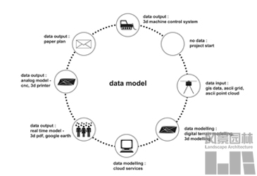
建筑领域对建筑信息模型(BIM)的讨论已经持续了很长时间,近期这一话题在基础设施项目的语境中也开始出现。因此,风景园林师们也应该对该问题有所认识。基础设施BIM的主要概念是允许一个项目的不同参与者应用同一个完整的数据模型。这些参与者包括规划师、土木工程师、结构工程师、环境工程师、风景园林师、施工人员,以及政府或城市的代表等。通过应用同一个模型,可在规划阶段就从BIM中检测到“冲突”的存在,而不必非等到建造过程中才在场地上发现。“智慧造景”是本文作者根据BIM首创的“智慧建造” (www.buildingsmart.org) 概念而发展的名词,用以阐述在风景园林领域内创造并应用电子数据模型的高效措施。智慧造景实质是基础设施BIM的组成部分(图01)。
2 数字地形模型
如今在瑞士,只要是稍具规模的施工场地(道路和停车场的建造,高尔夫球场和足球场等)就会普遍地应用三维全球卫星导航系统(3D GNSS)机械控制技术。除了内置于机械中的电子控制装置外,应用这项技术还需要一个参考站(基站)和一个组装在铲斗上的移动接收器(漫游器)。所接收到的两组数据组通过实时计算可以确立准确的定位(图02)。甚至是风景园林中常见的,自由的、自然式场地地形,也可以通过全球卫星导航(GNSS)机械控制系统实现厘米级误差的建造。地形建造过程既可以是全自动的,也可以是手动的。然而,实现这种建造的一项基本要求是设计师向施工队提供数字化地形模型(DTM)。施工队的测绘技师会用优盘将数据拷贝,这些数据在现场被“喂”进机械控制面板。这些工作测绘技师半个小时就可以完成,免除了之前三个人需要一整天才可以完成的打桩放线工作。然而,输入数据的准确性至关重要。数据组中的任何计算错误都会被直接建造成形。这种情况把施工队的责任转移到了设计师身上。所以,对于数据必须极其仔细。在新的三维建造过程中,为了有效地应用DTM数据,施工建设方、土木工程师、风景园林师和三维机械控制系统生产商所组成的团队需要形成一份共同文件,指出DTM必须如何准备。相关结果将在即将出版的第二版 Grading for Landscape Architects and Architects 一书中发表。
数字地形模型(DTM)在“智慧”造景中扮演了至关重要的角色。其原因在于:
(1)由于必须组织排水,所以风景园林的所有表面层都由坡面建成。DTM使得表面层的创建和工程的管理可以做到高效、无误,而且精确。
(2)挖掘机和推土机装备基于全球卫星导航系统(GNSS)的三维机械控制系统后塑造地形时,需要DTM数据。
(3)手工模型是风景园林师重要的设计工具,但是通过手工造成的地形变动情况必须转译成数据化的形式,以便于项目未来的发展。与DTM相结合的三维扫描技术为这种转译提供了方法。
数字化地形模型的基础是不规则三角网(TIN)。TIN的数据结构以两项元素为基础:点阵和边线。三角面将数据嵌合,以三角形组成表面层。点阵和边线越密集,模型的精确度越高。数字化地形模型的生成基本是自动的。数据来源可以是多样化的(准距仪、激光扫描数据、遥感数据或地理信息系统中以美国信息交换标准代码网格格式管理的既存数据)。在此需要明确强调的是,模型和计算的准确性也取决于输入数据的质量。软件的应用比较简单,只需要具有一定的成系统的“工程思维”就可以展开应用。DTM是基础设施数字化数据模型BIM的主要元素。
依靠高科技设备可以有很多方法形成地形数据。大多数方法都非常精确,但是也非常耗时且昂贵。最近,三维扫描软件在摄影测量学、图像处理和电脑视觉研究基础上得到发展,可以捕获物体并将其转换成三维数字数据。在风景园林学语境下,它会如何发挥作用呢?它可以对模型中或者场地上的地形进行360度的环绕拍摄以获取图像。经过多年的研究和实践,我们开发了Autodesk 123 Catch-3ds Max Design-Civil 3D这一技术框架。
三维扫描软件Autodesk 123D Catch 可以将所获取的数据发往云端进行处理。云端的程序对图像进行分析并寻找诸如物体边界、光影形态和其他特征点等特征元素。这些特征元素必须在所有图像中同时存在。然后,该软件会计算相机位置,并据此建立物体的坐标。根据坐标形成的面创造出形状。甚至可以加载正确的材质。所形成的模型应导入3ds Max Design进行删减小面,缩小文件量到可工作的大小。速度提高后的模型此后可在Civil 3D中作土方计算、坡度分析、等高线、断面和工程管理之用。经过Civil 3D地形命令优化和调整之后的模型既可以重新导入3ds Max Design用于云端渲染,又可以生成STL文件①。这类文件可以用于三维打印机输出模型。除此之外,数据也可以发送到施工现场,用以控制三维机械控制下的推土机和挖掘机进行现场施工。基于云技术的服务器可以提供经济、快速,并且相当准确的数据,这些数据可以用于DTM和基础设施BIM。
为了测试 Autodesk 123 Catch-3ds Max Design-Civil 3D工作流的准确性,在HSR地理技术实验室中,一个水桶被注入16升的水。将水泼出后,水桶中填入碎石,并翻转。围绕这座小碎石山一周(360°),大约拍摄25张照片。这意味着Autodesk 123 Catch的工作流可以用于体积的测量(图03-09)。
3 瑞士拉帕斯维尔花园中心停车空间设计
一位当地的风景园林师为瑞士拉帕斯维尔附近的一处花园中心设计了户外停车场。施工方应用了全球卫星导航系统三维机械控制推土机。这位风景园林师利用他的CAD系统无法创建准确的DTM模型。他5年前投资装备了新的计算机,但是,从此就再也没有费心去进行升级或者为他的雇员进行持续的教育。因此业主必须再雇佣一家土木工程公司来创建DTM模型。然后,施工队的测绘技师将数据拷贝到机械中,停车场就毫无困难地被建造完成了。创建DTM模型的额外费用是用那位风景园林师的佣金支付的(图10-11)。
4 结论
风景园林师必须改变他们的工作方式,开始智慧造景,以此保持前沿位置,并且成为基础设施BIM工程团队中的一分子。技术的发展来自于不同的方向,比如机械工程、图像处理和环境研究。这篇文章尚未涉及新的“智能”传感器驱动可持续性材料。不同软件程序、网络服务器、硬件设施和可持续性材料的结合利用是一种“糅合”(Mashup②),它对设计和建造领域而言是全新的概念。要应用Mashup并不断地紧跟新的发展趋势是当今的一项挑战,也是直面21世纪信息社会与国际化竞争的迫切要求。
注释
①译者注:STL文件格式是惠普实验室开发的一种文件格式,可用于打印输出。
②译者注:Mashup是一种网络应用程序开发的新现象,既整合应用多种已有资源的数据、功能、界面等,在开放性应用程序界面(API)下形成与原有资源的开发逻辑所不同的,更加丰富、多样的应用。
作者简介
彼得·派切克/1959年生/瑞士拉帕斯维尔应用科学大学教授
译者简介
郭湧/1983年生/男/清华大学建筑学院博士(北京 100081)
1 Smart Landscaping
Building Information Modeling (BIM) is being discussed in Architecture for a long time but recently the topic appears also in the context of infrastructure projects. Therefore it becomes an issue Landscape Architects have to be aware of. The main idea of BIM for Infrastructure is the usage of one complete data model by different project partners like Planners, Civil, Structural and Environmental Engineers, Landscape Architects, Building Contractors and government or city agencies. By using one model “clashes” can be detected in the BIM already during the planning phase and not on the site during construction. landscapingSMART is a term the author developed based on the BIM initiative buildingSMART (www.buildingsmart.org) for describing efficient ways to create a digital data model and for its usage within Landscape Architecture. landscapingSMART is part of BIM for Infrastructure (Fig.01).
2 Digital Terrain Model
Today in Switzerland on larger construction sites (road and parking space construction, golf courses and soccer fields) the usage of 3D GNSS machine control technology is mandatory. In addition to electronic control equipment mounted in the machine, it requires a reference station (the base station) and a mobile receiver (the rover) mounted on the blade. Two data sets are received and with real-time calculation an exact location is established (Fig.02). Even free, natural-style site grading, common in Landscape Architecture, can be carried out with accuracy to within centimeters using GNSS machine control systems. The grading can be either fully automatic or manual. One basic requirement, however, is that the designer provides the contractor with a DTM. The contractor’s survey technician copies the data onto a flash drive, which he or she then uses to “feed” the machine control panel on site. The survey technician needs half an hour for work that previously required three people for a whole day, making staking out work redundant. Nevertheless, the accuracy of the input data is crucial. Any calculation errors in the data set will simply be carried out, thus shifting responsibility from the contractor to the designer. As a consequence, extreme care must be taken with the data. A group of building contractors, civil engineers, landscape architects and 3D machine control system producers developed a paper how the DTM has to be prepared in order to be used efficiently in the new 3D construction process. The results are being published in the second edition of Grading for Landscape Architects and Architects.
The Digital Terrain Model (DTM) plays a major role in “smart” landscaping . The reasons are:
? All surfaces in Landscape Architecture are built with slopes, as the water has to run off. The DTM enables an efficient, correct and precise surface creation and project management.
? Diggers and dozers with Global Navigation Satellite Systems (GNSS) based 3D machine control systems need the DTM data for shaping the proposed site.
? Analog models are an important design tool for Landscape Architects, but terrain modifications created by hand have to be transferred to a digital form for further project development. 3D scan techniques in combination with DTM are the way to go.
A triangulated irregular network (TIN) is the basis of a digital terrain model. The TIN data structure is based on two elements: points and edges. The triangulation tessellates the data using triangles to form a surface. The more points and edges in a model, the more precise the model. The generation of a digital terrain model is mostly automatic. The origin of the input data varies (Tachymeter, Laser Scanning data, remote sensing or already existing data managed in form of ascii grid in a GIS). It should be explicitly emphasized that the precision of the model and calculations also depend on the quality of the input data. The software is easy to use, although you need a certain systematic “engineering mentality” in order to work with it. The DTM is the main element of a BIM for Infrastructure digital data model.
There are many ways to generate terrain data with high-tech equipment. Most of them are very precise but also very time consuming and expensive. Recently 3D scan software was developed based on research in Photogrammetry, Image Processing and Computer Vision. It can capture an object and transform it in 3D digital data. How does it function in a Landscape Architecture context? Images are taken 360 degrees around a landform in a model or on a site. After many years’ research and practice, we develop a framework of Autodesk 123 Catch–3ds Max Design-Civil 3D.
The 3d scan software Autodesk 123D Catch sends the data to a Cloud for processing. The program in the cloud analyses the images and looks for characteristic elements like edges of objects, light and dark pattern and other significant points. They have to appear on all images. The software then calculates the position of the cameras and based on it the coordinates of the object. The meshing of the coordinates creates the shape. Even the correct texture is applied. The model should be imported into 3ds Max Design for reducing the fine mesh into a working size. The faster model afterwards is used in Civil 3D for volume calculations, slope analysis, contours, profiles and project management. After optimizing and adapting the model with Civil 3D grading commands, it either gets reimported in 3ds Max Design for Cloud Renderings or a STL file is created. This file is used to print the model with a 3D Printer. Otherwise and addition the data is sent to the construction site for 3D machine control dozer and digging site work. Cloud based services provide inexpensive, fast and fairly precise data which can be used in DTM and BIM for Infrastructure.
In order to test the precision of the workflow Autodesk 123 Catch – 3ds Max Design – Civil 3D a bucket was filled with 16 liters of water in the HSR geo-technic lab. After spilling the water, the bucket was filled with gravel and turned over. Approximately 25 photos were taken 360 degrees around the little gravel hill. This means the workflow of Autodesk 123 Catch can be measured in an appropriate volume(Fig.03-09).
3 Parking Space Design in the Garden Center, Rapperswil, Switzerland.
A local Landscape Architect developed the design for a parking space outside a Garden Center close to Rapperswil, Switzerland. The contractor uses GNSS 3D machine controlled Dozers. The Landscape Architect was not able to create a precise DTM with his CAD system. Five years ago he invested in new computer equipment but never took care of updates or continuing education for his employees. Therefore a civil engineering company had to be hired to create the DTM. Afterwards the contractor’s survey technician copied the data to the machine and the parking space was built without any further problems. The extra costs for creating the DTM were taken from the Landscape Architect’s payment(Fig.10-11).
4 Conclusion
Landscape Architects have to change to a landscapingSMART workflow in order to stay ahead and be part of a BIM for Infrastructure project team. Developments come from very different directions like Mechanical Engineering, Image Processing and Environmental Research. The article did not even cover the new “intelligent” sensor driven sustainable materials. The combined usage of different software programs, internet services, hardware solutions and sustainable materials is a Mashup, which is completely new to the design and construction field. To work with this Mashup and to constantly keep up to date on new developments is the today challenge and in high demand in order to face the information society in the 21th century and the global competition.
Biography:
Peter PETSCHEK, born 1959, is a professor at the Department of Landscape Architecture, HSR University of Applied Sciences Rapperswil.
About the Translator:
GUO Yong,born in 1983, is a PhD of School of Architecture of Tsinghua University. ( Beijing 100081 )
 《风景园林》2013第1期导读
Leave a Reply